Trail Walking La Chapelle-Saint-Maurice - Roc des Bœufs et  - Photo
© OpenStreetMap contributors
Length
Length
8.7 km
Max alt
Max alt
1762 m
Uphill gradient
Uphill gradient
720 m
Km-Effort
Km-Effort  
18.3 km
Min alt
Min alt
1023 m
Downhill gradient
Downhill gradient
721 m
Boucle
Boucle
Yes
Creation date :
2020-05-21 08:59:44.0
Updated on :
2020-05-21 13:52:31.37

(1 Reviews)

Walking
Walking
4h19
Difficulty : Difficult

Scan this QR Code to open this trail in the SityTrail application

FREE GPS app for hiking

Logo SityTrail SityTrail

IGN / Geographical institutes

Download SityTrail from the App Store Download SityTrail from Google Play

Logo SityTrail SityTrail World

The world is yours!

Download SityTrail from the App Store Download SityTrail from Google Play Download SityTrail on Huawei AppGallery

About

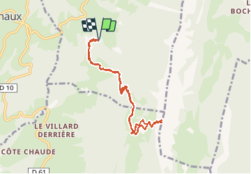
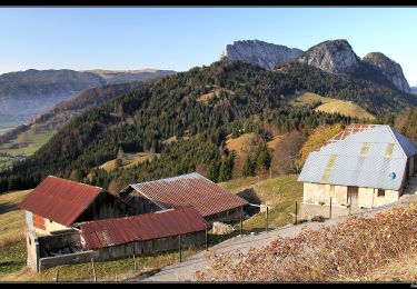
Trail Walking of 8.7 km to be discovered at Auvergne-Rhône-Alpes, Upper Savoy, La Chapelle-Saint-Maurice. This trail is proposed by sandra_leb.

Elevation profile

Positioning

Country:
France
Region :
Auvergne-Rhône-Alpes
Department/Province :
Upper Savoy
Municipality :
La Chapelle-Saint-Maurice
Location:
Unknown
Start:(UTM)
278450 ; 5072296 (32T) N.

Comments

Please log in to post a review or rate the element


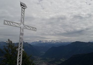
Superbe panorama à l’arrivée Bien escarpe sur la fin Attention à ceux qui ont le vertige


Trails nearby

Trail Mountain bike Lathuile - VTT des sources du lac d'Annecy - Photo
Mountain bike
GUIDE
pascalou73

Mountain bike

Medium
(2)
Lathuile, Auvergne-Rhône-Alpes, Upper Savoy, France
27 km | 31 km-effort
2h 3min
Yes
Trail Walking Duingt - Montagne d'Entrevernes - Photo
Walking
gebocarm

Walking

Medium
(2)
Duingt, Auvergne-Rhône-Alpes, Upper Savoy, France
9.6 km | 19.3 km-effort
3h 53min
Yes
Trail Walking Lathuile - LaThuile - Photo
Walking
GUIDE
HERRY

Walking

Easy
Lathuile, Auvergne-Rhône-Alpes, Upper Savoy, France
10.2 km | 18.4 km-effort
3h 52min
Yes
Trail Cycle Lathuile - Le tour du lac d'Annecy - Photo
Cycle
GUIDE
pascalou73

Cycle

Easy
Lathuile, Auvergne-Rhône-Alpes, Upper Savoy, France
38 km | 45 km-effort
2h 28min
No
Trail Walking Bellecombe-en-Bauges - La croix du Roy  - Photo
Walking
Annie21

Walking

Medium
Bellecombe-en-Bauges, Auvergne-Rhône-Alpes, Savoy, France
16 km | 26 km-effort
5h 30min
Yes
Trail Walking Bellecombe-en-Bauges - Tour de BancPlat, Dent des portes en partant du petit reposoir  - Photo
Walking
Zasa

Walking

Medium
Bellecombe-en-Bauges, Auvergne-Rhône-Alpes, Savoy, France
18.4 km | 34 km-effort
6h 0min
Yes
Trail Walking Doussard - tour de la Pointe de Banc Plat - Photo
Walking
Mariolebeno

Walking

Very difficult
(1)
Doussard, Auvergne-Rhône-Alpes, Upper Savoy, France
16.9 km | 30 km-effort
6h 34min
No
Trail Touring skiing Bellecombe-en-Bauges - la dent des portes et sous le Trelod - Photo
Touring skiing
nadd73

Touring skiing

Medium
Bellecombe-en-Bauges, Auvergne-Rhône-Alpes, Savoy, France
12.9 km | 29 km-effort
3h 52min
Yes
Trail Walking Bellecombe-en-Bauges - Crêt du Char - Photo
Walking
flip38

Walking

Medium
(1)
Bellecombe-en-Bauges, Auvergne-Rhône-Alpes, Savoy, France
14.3 km | 24 km-effort
5h 27min
Yes


Close
My subscriptions